On this page
Field Studies Council (FSC):
Fold-Out Charts: RegionsThis page lists fold-out charts published by the FSC that describe the plants and animals found in a specific region. These charts all include some information about birds. The FSC has produced a series of fold-out charts designed to help users identify a wide range of plants and animals. Each chart is laminated to make it splashproof and robust for use outdoors. Clear colour illustrations and text by experts in the subject make these valuable resources for all age groups.
FSC pages on the site
- Fold-Out Charts: birds
- Fold-Out Charts: regions
- Fold-Out Charts: others
For more information about the Field Studies Council and to buy publications and other items see the FSC web site
|
|
|
|
Guide to Shapwick Heath National Nature ReserveJulie Merrett, Simon Clarke
Illustrations: Mike Langman, Chris Shields, Lizzie Harper
Occasional Publication Volume 172
Field Studies Council
2016
"Shapwick Heath National Nature Reserve is a magnificent 530 hectare wetland reserve situated at the heart of the Somerset Moors and Levels. It forms part of the 'Avalon Marshes', one of the largest areas of wetland in the UK. This 12-panel fold-out chart features many of the special animals and plants for which this area is justly famous. Text on the reverse side reviews the major habitats found on the resever, as well as including a timeline of the reserve's history from the end of the last glacial period onwards."
|
Buy from amazon.co.uk 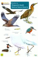
|
|
Features Of The Serpent Trail
Illustrations: Carol Roberts, Mike Langman, Richard Lewington, Chris Shields
Occasional Publication Volume 151
Field Studies Council
2012
"This long-distance footpath in Surrey, West Sussex and Hampshire, the Serpent Trail links the remaining fragments of lowland heath in the western part of the South Downs National Park. This new 12-panel fold-out chart features some of the special animals and plants for which this area is justly famous."
|
Buy from amazon.co.uk 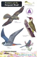
|
|
Features Of The Meres and Mosses of Shropshire, Cheshire and StaffordshirePete Boardman, Joan Daniels
Occasional Publication Volume 147
Field Studies Council
2012
"This 12 panel fold-out chart showcases the wildlife of the Meres and Mosses landscape of Shropshire, Cheshire and Staffordshire. Although not well known outside the local area, this landscape has the largest groups of natural lakes and wetlands in England and the highest density of ponds anywhere in Europe."
|
Buy from amazon.co.uk 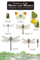
|
|
Features Of The South Downs Way
Illustrations: Mike Langman, Carol Roberts, Richard Lewington
Occasional Publication Volume 146
Field Studies Council
2011
"The South Downs National Park was designated in March 2010. This fold-out chart is aimed at walkers and visitors to this area. It features artwork to help identify the common birds, livestock, moths and butterflies and farm crops. Included are a map of the South Downs Way National Trail and a height profile of the walk."
|
Buy from amazon.co.uk 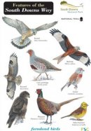
|
|
Features of the Shropshire Hills: The Stiperstones and Long MyndPete Boardman
Occasional Publication Volume 125
Field Studies Council
2008
"Designated an Area of Outstanding Natural Beauty, the Shropshire Hills extend from the Wrekin to the Clun Forest, and from Stapeley Common to the Clee Hills. This dramatic and at times wild landscape is a haven for wildlife, rich in history, but is relatively poorly known, even within the West Midlands region. Produced in partnership with Shropshire Hills AONB, the National Trust and Natural England, this 12-panel chart will be of interest to all visitors to the Stiperstones and Long Mynd."
|
Buy from amazon.co.uk 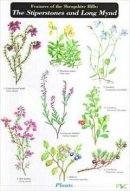
|
|
Features of the Pennine WaySimon Norman
Illustrations: Mike Langman, Carol Roberts
Occasional Publication Volume 103
Field Studies Council
2006
"Produced in partnership with the Countryside Agency and Natural England, this unique fold-out chart is aimed at Pennine Way walkers who wish to find out a little more about the wildlife and landscapes of the areas through which they are walking. It features artwork to help identify the common birds, upland sheep, other mammals and plants of the Pennine Way; a written description of the physical and human features of the major natural areas through which the Pennine Way passes."
|
Buy from amazon.co.uk 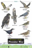
|
|